How GNSS Positioning Works in Mining
How satellite positioning works, what affects accuracy, and where it fits in fleet management.
Understanding Satellite Positioning
Satellite positioning is the foundation of every modern mining fleet management system. Whether tracking haul trucks in an open pit or monitoring equipment across a spread-out site, the ability to know where machines are in real time underpins dispatching, safety systems, and production reporting.
This article covers how satellite positioning works at a fundamental level. Dedicated articles in this section go deeper on specific topics including multi-constellation GNSS, correction techniques, multipath, dilution of precision, antenna placement, and GPS-denied environments underground.
How Satellite Positioning Works
A positioning receiver calculates its location by measuring the time it takes for signals to travel from satellites orbiting the Earth. Each satellite carries atomic clocks accurate to nanoseconds and continuously broadcasts two pieces of information: the precise time the signal was transmitted, and the satellite’s orbital position at that moment. The receiver compares arrival time against transmission time to calculate signal travel distance. Since the signals travel at the speed of light, even a small timing error translates to a large position error, which is why atomic clock precision matters.
The mathematical process is called trilateration. One satellite places the receiver somewhere on a sphere. Two satellites narrow it to a circle. Three satellites reduce it to two points. A fourth satellite resolves the ambiguity and corrects for clock error in the receiver itself. In practice, mining receivers track well beyond the minimum four, often locking onto 20 or more satellites simultaneously for improved accuracy and redundancy.
The GNSS Constellations
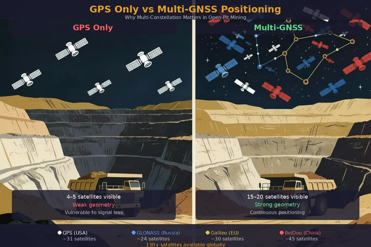
Everyone in mining calls it GPS, but GPS is just one system. It is the American one. There are four separate satellite constellations orbiting the Earth, each built and operated by a different country or region. The umbrella term for all of them is GNSS, which stands for Global Navigation Satellite Systems. A modern positioning receiver does not pick one. It listens to all of them at the same time and uses every satellite it can see to calculate a position.
| Constellation | Country / Region | Satellites | Altitude | Orbit Type |
|---|---|---|---|---|
| GPS | United States | ~31 | 20,200 km | Medium Earth Orbit (MEO), 6 planes |
| GLONASS | Russia | ~24 | 19,100 km | MEO, 3 planes |
| Galileo | European Union | ~30 | 23,222 km | MEO, 3 planes |
| BeiDou | China | ~35 (mid-40s with spares) | 21,150 km (MEO) | MEO + Geostationary (GEO) + Inclined Geosynchronous (IGSO) |
Modern receivers track all available constellations simultaneously, combining observations into a single position solution. Where a GPS-only receiver might see 8 to 12 satellites, a multi-constellation receiver routinely tracks 25 to 40. In mining, where deep pits, steep terrain, and large structures block portions of the sky, this additional satellite visibility improves position accuracy and availability. The benefits and trade-offs of multi-constellation tracking are covered in detail in Beyond GPS: The Global GNSS Landscape.
Position Accuracy
It is worth distinguishing between accuracy and precision, because the two terms mean different things in positioning. Accuracy is how close a measured position is to the true location. Precision is how consistently the receiver produces the same result when conditions are unchanged. A system can be precise but inaccurate (repeatedly placing a truck five metres from where it actually is) or accurate on average but imprecise, with positions scattering around the true location. Effective machine guidance and fleet tracking require both.
Standard autonomous positioning, using satellite signals alone with no correction source, typically achieves horizontal accuracy of 3 to 5 metres under good conditions. This is adequate for general fleet tracking, dispatching, and route monitoring but insufficient for precision tasks like drill positioning or grade control.
Several factors degrade accuracy in mining environments. Signal blockage from pit walls reduces the number of visible satellites and weakens the geometric distribution used to calculate position, a concept measured as Dilution of Precision (DOP). Atmospheric delays from the ionosphere and troposphere introduce timing errors. Multipath (signals bouncing off haul trucks, structures, or pit walls before reaching the antenna) creates measurement ambiguity. Antenna placement on the machine itself also affects signal quality.
Enhanced positioning techniques using ground-based reference stations or satellite-based correction services can reduce errors to centimetre levels. These techniques, including Differential GNSS and Real-Time Kinematic (RTK) positioning, are covered in dedicated articles.
Update Rates
Receivers output position data at a fixed rate, measured in hertz. Standard mining receivers operate at 1 to 10 Hz, meaning the position refreshes one to ten times per second. Each update includes latitude, longitude, altitude, velocity, and heading. Higher update rates provide smoother tracking data but consume more processing power and communications bandwidth. Most fleet management applications work well at 1 Hz. Machine guidance and autonomous haulage systems typically require 5 to 10 Hz or higher.
Integration with Fleet Management Systems
The GNSS receiver is one component in a larger positioning and data chain. In a mining fleet management system, the receiver feeds position data to an onboard computer that combines it with other sensor inputs: inertial measurement units for dead reckoning during brief signal loss, proximity detection systems, and operational sensors reporting engine status, payload, and fuel consumption. This combined data stream is transmitted to a central server over the site radio network, where it is archived and displayed in real time.
Fleet managers use this information to monitor equipment positions on a digital mine model, allocate trucks to shovels, identify delays, enforce speed limits through geofencing, and generate production reports. Historical position data feeds into haul road analysis, cycle time optimisation, and conformance checks against mine plans. The accuracy and reliability of the underlying GNSS position directly affects the quality of every downstream function.
The distinction between fleet-level tracking and machine-level guidance (two different applications of the same positioning technology) is covered in Two Different GPS Applications.
Key Takeaways
- Confirm your receivers track all four GNSS constellations, not just GPS. Multi-constellation tracking improves satellite visibility in deep pits where GPS alone may drop below the minimum for a reliable fix.
- Know the difference between autonomous and corrected accuracy. Standalone GNSS gives 3 to 5 metres, adequate for fleet tracking and dispatch. Drill positioning, grade control, and machine guidance need RTK corrections for centimetre-level accuracy.
- Check satellite geometry, not just satellite count. A receiver can see 15 satellites and still produce a poor position if they are all clustered in one part of the sky. Dilution of Precision (DOP) is the metric to watch.
- Treat the GNSS antenna as safety-critical infrastructure. A loose mount, a damaged cable, or a poorly placed antenna degrades every downstream function: dispatching, proximity detection, speed enforcement, and production reporting.
- Audit position quality quarterly. Compare GNSS-reported positions against known survey points. Drift in base station coordinates or degraded antenna performance shows up as a slow, systematic position error that nobody notices until reconciliation breaks.